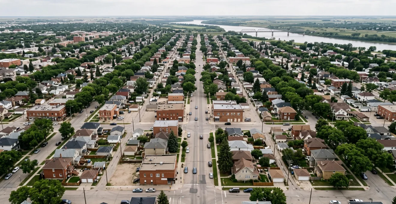
Winnipeg’s grid-like streets make everyday travel more flexible by offering multiple routes between many neighbourhood destinations. A blocked intersection does not always require a lengthy diversion: in connected areas, drivers and cyclists can often reach another street running in the same direction. However, rivers, railway corridors, bridge locations and suburban street patterns mean that alternatives are not equally useful everywhere.
The city’s network also has an important historical distinction. Despite its many rectangular blocks, Winnipeg does not use a continuous system of consecutively numbered streets. Its present-day navigation depends on named roads, actual connections and the larger arterial network.
Understanding how these elements interact helps residents decide when to stay on a busy main road, when to use an appropriate parallel route and when adjusting departure time may be more effective than changing streets. The same reasoning applies to cycling, although bicycle facilities, permitted movements and traffic exposure require separate consideration.
Winnipeg street-grid travel essentials
- Connected grid-like neighbourhoods provide route choices, but rivers, railways and disconnected streets can eliminate apparent shortcuts.
- Arterials usually provide better continuity for longer trips, while suitable parallel streets can help bypass localized disruptions.
- Reliable alternatives depend on legal turns, intersection controls, seasonal conditions and the safety of residential streets.
- Why Can Winnipeg’s Street Grid Make Some Detours Easier Than Others?
- How Can Drivers Use Winnipeg’s Street Grid to Avoid a Blocked Route?
- Main Road or Parallel Street: Which Route Works Better in Winnipeg Traffic?
- Shortcut Mistakes That Can Create Problems on Winnipeg Residential Streets
- When Is a Parallel Winnipeg Street a Better Option Than Your Usual Route?
- How Do Winnipeg’s Key Arterial Routes Shape Cross-City Travel?
- Different Route or Different Time: Which Better Reduces Winnipeg Commute Delays?
- How Can You Plan a Backup Route for a Busy Winnipeg Arterial?
Why Can Winnipeg’s Street Grid Make Some Detours Easier Than Others?
Some Winnipeg detours are easier because connected rectangular blocks offer nearby parallel streets and several possible turning points. Others are difficult because rivers, railway lines, restricted movements or disconnected neighbourhood roads interrupt those connections. The practical difference is not simply how close another street appears on a map, but whether it actually reaches the destination.
In neighbourhoods with a regular grid, an obstruction on one street may be bypassed by turning onto a cross street, travelling to a suitable parallel road and returning after the blockage. This arrangement can spread local traffic across more than one available connection instead of forcing every trip onto a single collector.
Winnipeg’s street history matters when interpreting that pattern. According to the Manitoba Historical Society‘s history of Winnipeg streets, the city introduced numbered streets in 1891 but largely restored original street names in 1893. The current network should therefore not be treated as a consecutively numbered grid, and drivers cannot reliably navigate by assuming that street numbers increase in a particular direction.
Historically, avenues were generally associated with east-west orientation and streets with north-south orientation. Yet modern street names and alignments do not create a universal directional rule. Actual street connections, rather than naming conventions, determine whether an east-west or north-south detour is easier.
The Red and Assiniboine rivers introduce a different constraint. Where a trip requires a bridge, moving to a neighbouring street may not provide another river crossing. The alternative might ultimately reconnect with the original route at the same congested bridge approach.
Railways create similar interruptions. A street can appear continuous across several blocks but encounter a level crossing, railway right-of-way or disconnected segment. A useful detour must preserve the necessary crossings, not merely follow a parallel alignment.
Neighbourhood structure adds another distinction. Parts of Winnipeg’s older urban fabric feature connected rectangular blocks, whereas areas of St. Vital and Charleswood also contain curved collectors, crescents and cul-de-sacs. These layouts make nearby parallel alternatives less predictable.
- Connected grid: Several possible turns may bypass a localized obstruction.
- River crossing: The available bridge may determine the entire diversion.
- Railway barrier: A nearby road may encounter the same crossing or terminate before reaching it.
- Curvilinear subdivision: A neighbouring street may not connect to the next collector.
A reliable detour is defined by its complete path, not by the visual regularity of the blocks surrounding the obstruction.
How Can Drivers Use Winnipeg’s Street Grid to Avoid a Blocked Route?
Drivers can use Winnipeg’s connected street grids to bypass a blocked road by identifying a legal cross street, moving onto a suitable parallel route and returning beyond the obstruction. Before committing, they should confirm that the replacement street continues through the affected area and does not encounter the same railway crossing, bridge bottleneck or closure.
Imagine a hypothetical trip through a rectangular residential grid where roadwork blocks the next intersection. If the surrounding streets remain connected, the driver can turn before the closure, travel to another suitable street and rejoin the intended direction farther ahead.
This is a street-level diversion. It works best for an isolated obstruction and becomes less effective when construction extends across several intersecting roads.
A practical approach has four parts:
- Identify the location and apparent extent of the obstruction before reaching the queue.
- Find a permitted turn that leads to an appropriately connected parallel street.
- Check for one-way restrictions, railway crossings, school zones and access limitations.
- Confirm that a legal connection exists back to the intended route beyond the affected segment.
Street names and recognizable intersections are more dependable positioning references than presumed numbering patterns. Winnipeg’s former numbered-street arrangement does not provide a modern navigation shortcut. Drivers should use known cross streets, route signs and a current map to understand their position.
Railway activity deserves particular attention. In August 2026, the City announced predictive crossing alerts for three Winnipeg locations. The City of Winnipeg announcement on predictive rail-crossing alerts identifies Ravenhurst north of Dugald Road, the Marion Street corridor between Archibald Street and Lagimodiere Boulevard, and McGillivray at Pembina Highway.
3 crossing areas
The August 2026 predictive-warning deployment identifies three specific railway-crossing areas, rather than providing universal coverage across Winnipeg.
City of Winnipeg, August 21, 2026.
Roadside TRAINFO beacons and digital message boards provide advance warnings at the identified locations. These alerts allow drivers to consider a different route before reaching railway activity, although they do not guarantee that the alternative will be faster or unobstructed.
Visible congestion can also inform a decision. A queue extending through several intersections suggests a broader problem than a brief delay at one signal. However, a driver should assess the situation from a safe position and avoid reacting with sudden turns or improvised manoeuvres.
When several nearby streets share the same barrier, shifting to another complete corridor is generally a more promising strategy than repeatedly changing blocks.
Main Road or Parallel Street: Which Route Works Better in Winnipeg Traffic?
A Winnipeg arterial is generally the more suitable option for longer trips because it is intended to carry through traffic and provide connections across larger parts of the city. A parallel street may be useful for a short, localized disruption, but frequent stops, lower speed limits, restricted turns and neighbourhood safety concerns can outweigh any apparent distance advantage.
Major routes such as Route 90, Kenaston Boulevard, Pembina Highway, Portage Avenue and Henderson Highway form important parts of Winnipeg’s travel network. Their intersections and traffic controls serve substantial movements between neighbourhoods and destinations.
By contrast, residential streets primarily provide local access. Even when they run parallel to an arterial, they may not be appropriate substitutes for sustained through traffic.
The following comparison helps explain how route choice changes with the journey.
| Decision factor | Main arterial | Residential parallel |
|---|---|---|
| Primary function | Longer-distance movement and network connections | Local neighbourhood access |
| Intersection pattern | Often includes signalized major intersections | May include frequent stop-controlled junctions |
| Through-route continuity | Generally stronger across longer distances | Must be checked block by block |
| Traffic conditions | Can experience concentrated queues | May offer an alternative to isolated delays |
| Safety considerations | Busy intersections and substantial traffic volumes | Pedestrians, cyclists, driveways and local activity |
| Typical use | Cross-city or longer corridor trips | Short, appropriate and legal local diversions |
The important trade-off is **intersection delay versus through-route continuity**. A seemingly empty parallel street can still require frequent full stops, additional turns and a slow return to the main corridor.
One way to compare two potential routes is to count the stop-controlled and signalized intersections along each complete path. Dividing those counts by route length gives a rough picture of how frequently drivers encounter controls, although it cannot predict actual journey times without observing traffic conditions.
Time of day matters as well. During quieter periods, remaining on an arterial may avoid unnecessary turns. During heavy congestion on corridors such as Main Street or Osborne Street, a connected alternative may become attractive for part of a journey, provided it is safe and permitted.
The answer changes for cyclists. A quiet parallel street may reduce exposure to heavy motor traffic, but its suitability also depends on intersection crossings, surface conditions and the availability of appropriate cycling connections. A shorter route is not necessarily a safer cycling route.
For both motorists and cyclists, the choice should include the effects on neighbourhood streets rather than concentrating exclusively on individual travel time.
A residential parallel should be chosen because it is genuinely appropriate for the journey, not simply because the arterial appears busy.
Shortcut Mistakes That Can Create Problems on Winnipeg Residential Streets
The most common problems with residential shortcuts arise when drivers overlook seasonal conditions, school-zone rules, prohibited movements or streets that do not connect as expected. Winnipeg’s grid-like blocks can make a shortcut appear straightforward, but a route that is legal and convenient in one season or at one hour may be unsuitable at another time.
Winter illustrates the difference between apparent and practical accessibility. Snow accumulation can narrow a residential roadway, obscure curb edges and reduce visibility near intersections. A route that provides comfortable passage during summer may become difficult when vehicles are parked beside snow ridges.
Unplowed or poorly maintained lanes should never be treated as guaranteed alternatives. Railway crossings, stop-controlled intersections and slippery surfaces also require additional caution.
**Posted school-zone restrictions** are particularly important. The Winnipeg Police Service school-zone road-safety announcement states that the maximum speed is 30 km/h in posted reduced-speed school zones from 7 a.m. to 5:30 p.m., Monday through Friday, September through June.
These conditions apply where the relevant reduced-speed restrictions are posted, not automatically to every residential street near a school. Drivers should follow actual signs and must not assume that playground areas operate under an identical schedule.
30 km/h
Maximum speed in Winnipeg’s posted reduced-speed school zones during the applicable weekday periods from September through June.
Winnipeg Police Service, September 8, 2026.
Another mistake is assuming that a straight street necessarily remains open throughout its apparent length. Railway rights-of-way, dead ends, one-way sections and turning restrictions can invalidate a shortcut. A route may also require crossing a busy arterial at a location where a safe or permitted movement is unavailable.
Residential shortcutting has consequences beyond the individual journey. Winnipeg uses traffic-calming measures to slow or reduce traffic through residential areas and improve safety for pedestrians, cyclists and motorists.
According to the City of Winnipeg traffic-calming information, these measures can include speed humps, bump-outs and turn restrictions. Such interventions may change whether a formerly convenient route remains practical or permitted.
Neighbourhoods such as River Heights and Wolseley contain residential streets where through drivers should be especially mindful of local activity. The presence of a rectangular grid does not establish that particular streets experience documented shortcutting complaints or are approved diversion corridors.
The most responsible detour is not merely one that avoids a queue; it is one that remains safe, legal and appropriate for the type of street being used.
When Is a Parallel Winnipeg Street a Better Option Than Your Usual Route?
A parallel Winnipeg street becomes a worthwhile alternative when a localized delay substantially affects the usual road and the replacement provides a complete, legal and reasonably direct connection. It is less attractive when congestion extends across the entire corridor, the diversion introduces many stops or neighbourhood conditions make through driving inappropriate.
Drivers can evaluate several recognizable triggers without assuming that every visible queue requires a route change.
- Localized roadwork: A closure affects one segment, while surrounding connections remain usable.
- Railway activity: An alternative avoids the affected crossing rather than approaching the same rail line nearby.
- Event-related traffic: A different access route may avoid congestion near destinations such as The Forks, depending on the event and road restrictions.
- Queue spillback: Congestion reaches several upstream intersections, making it useful to assess another corridor.
- Seasonal disruptions: Snow conditions or construction change the suitability of the habitual route.
These are reasons to investigate an alternative, not guarantees of a faster journey. The quality of the replacement route must be established separately.
Familiarity helps. A resident who regularly uses Portage Avenue, for example, may know a connected local route suitable for reaching a nearby destination. That knowledge includes stop locations, permitted turns and the final access point. An unfamiliar diversion suggested during a stressful traffic incident may hide limitations that are not immediately obvious.
**Trip length also changes the calculation.** For a very short journey, the additional turns needed to reach a parallel street may erase any benefit. For a medium-length journey with one localized bottleneck, an established alternative can be useful. For a long cross-city trip, changing major corridors may matter more than changing one residential street.
A practical verification habit is to travel the prospective alternative during ordinary conditions, recording its normal duration and potential weak points. This creates a useful reference when congestion later affects the usual road, without claiming that a single trial predicts every future trip.
A parallel route should also be judged in both directions. Legal turning movements, intersection controls and traffic patterns may make an outbound diversion different from the return journey.
Knowing when to remain on the original route is just as valuable as having several possible alternatives.
How Do Winnipeg’s Key Arterial Routes Shape Cross-City Travel?
Winnipeg’s arterial roads shape cross-city travel by concentrating longer-distance movement onto corridors that connect neighbourhoods, employment areas, commercial destinations and major crossings. The surrounding street grid provides local access to these roads, but rivers, railway barriers and bridge approaches limit how freely traffic can transfer between corridors.
Several well-known roads illustrate the structure of the network:
- Kenaston Boulevard and Route 90: Important north-south and western-network connections.
- Portage Avenue: A major east-west approach linking western areas with central Winnipeg.
- Pembina Highway: A principal southern corridor connecting communities and destinations along its length.
- Henderson Highway: An important route serving northeastern areas.
- Main Street: A central and northern corridor connecting significant urban destinations.
These routes do not function independently. Their performance is influenced by connecting intersections, access roads, bridge approaches and the distribution of surrounding trips.
The Red River and Assiniboine River impose particularly important geographic constraints. Drivers cannot simply follow any parallel street to cross a river. They must use an available bridge with suitable connecting roads, which can concentrate traffic at certain approaches.
Railways create a related issue. Road users may have numerous choices within a neighbourhood but comparatively fewer convenient ways to cross a railway corridor. Underpasses and grade-separated crossings can therefore influence the usefulness of a longer route, even if the alternatives cover similar map distances.
Travel demand also changes during the day. Trips toward central employment destinations may contribute to inbound congestion during morning commuting periods, while outbound movements can become more prominent later. However, Winnipeg’s journey patterns vary by corridor, destination and day; a universal directional pattern should not be assumed for every road.
The relationship between the grid and the arterial system is best understood as two interconnected levels. Local streets provide access and short alternative paths, while arterials support broader movement through the city.
A route planned entirely around residential shortcuts can become inefficient when it repeatedly crosses busy arterials. Conversely, relying exclusively on main roads can be inconvenient for destinations located within a connected neighbourhood grid.
For cyclists, the same arterial geography matters, but safe crossings and suitable cycling connections should take precedence over the apparent directness of a motor-vehicle route.
The most practical journey combines suitable local access streets with the larger corridors needed to cross the city efficiently.
Different Route or Different Time: Which Better Reduces Winnipeg Commute Delays?
Changing departure time may be more effective for predictable rush-hour congestion, while changing route can be more useful for unexpected incidents or localized closures. A time shift changes when the traveller enters the network; a route change changes where the traveller encounters traffic. Neither approach guarantees a shorter journey, and some commuters cannot adjust their schedules.
For a regular commute affected by recurring congestion, starting earlier or later can be worth testing. A shift of 15–30 minutes is a practical trial interval, not a documented Winnipeg-wide estimate of the time required to avoid peak traffic.
The driver can compare several ordinary journeys at different departure times, considering travel duration, arrival requirements and consistency rather than selecting the single fastest trip.
Route changes serve another purpose. When an unexpected closure blocks one intersection, the grid may provide a nearby legal connection around it. The benefit is limited by the capacity and continuity of the alternative, especially if several diverted vehicles use the same residential street.
Winnipeg’s interconnected older neighbourhoods can offer more local options than a subdivision with a single collector exit. However, this does not mean the entire city functions as a fully connected grid or that local alternatives bypass its river and railway bottlenecks.
The choice can be organized around the type of delay:
| Situation | Change route | Change departure time |
|---|---|---|
| Recurring rush-hour queue | Useful if a suitable alternative exists | Worth testing if the schedule is flexible |
| Unexpected localized closure | Often worth investigating | May not help once the trip has begun |
| Shared bridge bottleneck | Requires another viable crossing | May help if congestion varies by time |
| Fixed work or school arrival | May be the practical available adjustment | Constrained by arrival requirements |
| Winter road disruption | Depends on actual road conditions | May allow conditions to improve if delay is possible |
For commuters with fixed shifts, school drop-offs or transit connections, departure-time flexibility may be minimal. Their more realistic options include a pre-verified route, improved awareness of incidents and allowing a reasonable schedule buffer.
For those with flexible hours, experimenting with departure times before adding a complicated diversion is a sensible first step. Both approaches can also be combined: use a preferred departure window for normal days and retain a tested alternative for unusual disruptions.
A dependable commute strategy should prioritize consistency and safe connections, not only the shortest travel time recorded on an unusually favourable day.
Key takeaways before planning your backup
- Choose an alternative that crosses the same necessary geographic barriers through a different usable connection, when one exists.
- Maintain separate options for small local incidents and major corridor-wide closures.
- Review alternatives as construction, winter conditions and posted restrictions change.
How Can You Plan a Backup Route for a Busy Winnipeg Arterial?
Plan a Winnipeg arterial backup by identifying the vulnerable segment of your usual journey, tracing a complete alternative corridor and verifying every major crossing along it. Keep one nearby street-level diversion for localized incidents and, where the network allows, a separate corridor-level alternative for broader disruptions. Test both before depending on them during congestion.
Begin with the specific portion of an arterial that creates difficulty. A backup for a busy intersection is different from a backup for a river crossing or a major construction closure.
For example, a hypothetical driver travelling along Pembina Highway might identify a routine intersection delay and a separate contingency for disruption near a railway crossing. The first problem may allow a short local diversion; the second requires checking whether the alternative actually avoids the affected crossing.
The two-level approach prevents a common planning error: choosing a parallel road that ultimately returns to the same blocked location.
On a route involving the Red or Assiniboine River, the backup should explicitly identify the available bridge and its connecting streets. Without that verification, a seemingly reasonable alternative may require substantial backtracking.
Seasonal review is equally important. Summer construction can affect arterials and connecting streets simultaneously. Winter snow accumulation, restricted parking conditions and reduced usable road width can change the practicality of a residential alternative. Locations such as St. Mary’s Road or the Disraeli corridor illustrate why route-specific conditions must be checked rather than assumed.
Build a five-step Winnipeg backup-route plan
- Mark your usual arterial segment. Save the start, end and most troublesome intersection as a clearly identified primary route.
- Identify a local diversion. Record one connected, legally permitted street-level alternative and where it rejoins the original road.
- Identify a corridor-level option. Mark a different suitable arterial and all necessary river or railway crossings on a second saved route.
- Check the weak points. Note important stops, restricted turns, school zones, seasonal constraints and other features requiring verification.
- Validate and review. Compare the alternatives during an ordinary journey and update the saved plan when conditions or restrictions change.
The result should be a simple set of known options rather than a complicated collection of possible turns. A saved route is useful only if its connections remain accessible and its limitations are understood.
For cyclists, an equivalent plan should identify suitable crossings, cycling connections and manageable intersections instead of assuming that a motor-vehicle detour is appropriate.
Review your usual journey, save one appropriate local alternative and one broader option where possible, and verify their suitability under ordinary conditions before an unexpected disruption makes a decision urgent.
Does Winnipeg still have a numbered street grid?
No. Winnipeg has many grid-like streets, but its short-lived numbered-street system was largely abandoned in 1893. Modern navigation relies on named streets and verified connections rather than a continuous sequence of numbered roads.
Can a nearby parallel street always bypass a Winnipeg railway crossing?
No. A neighbouring road may encounter the same railway corridor, another level crossing or a disconnected segment. The alternative must be checked for an unobstructed and permitted crossing. Winnipeg’s predictive railway warnings cover specific locations, not every crossing in the city.
Are Winnipeg residential streets always slower than arterials?
Not necessarily. A residential street may bypass a localized arterial delay, but frequent stops, restricted turns, lower speeds and local activity can offset the advantage. A complete route comparison is more meaningful than comparing traffic at one intersection.
Do Winnipeg school-zone speed limits apply throughout the summer?
The Winnipeg Police Service’s September 2026 guidance specifies a 30 km/h maximum in posted reduced-speed school zones from 7 a.m. to 5:30 p.m., Monday through Friday, September through June. Drivers must follow the applicable signs and should not assume identical restrictions for every school-area or playground-area road.
How often should a Winnipeg driver review a backup commute route?
A review at seasonal changes is a practical habit, especially before winter and during road-construction periods. It is also sensible to check the route after known closures or traffic-control changes. This is a planning recommendation rather than a mandatory municipal review schedule.