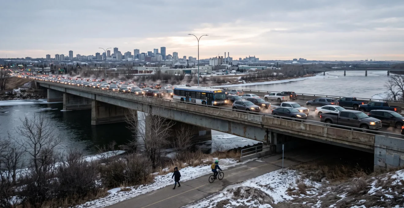
Winnipeg’s transportation network moves people and goods through an interconnected system of streets, river crossings, public transit routes, walking and cycling facilities, rail connections, and freight corridors. Each component serves different trips, but none operates entirely independently. A disruption on a major road can affect bus schedules, freight deliveries, neighbourhood traffic and access to destinations far beyond the original incident.
The city’s geography makes these connections particularly important. The Red and Assiniboine rivers shape travel routes, while major corridors such as Portage Avenue and Kenaston Boulevard carry different combinations of commuter, commercial and local traffic. Seasonal construction and demanding winter conditions add another layer of complexity.
Winnipeg’s Transportation 2050 framework recognizes these relationships by coordinating planning for motor vehicles, transit, active transportation and goods movement. Understanding how those networks interact helps residents choose practical travel options and businesses assess the reliability of their transportation connections.
Winnipeg transportation network at a glance
- Connectivity determines resilience: bridges, arterial roads and transit connections can spread the effects of a disruption well beyond its immediate location.
- The best travel option depends on the journey: distance, route availability, winter maintenance, transfers and arrival-time requirements all matter.
- Reliable mobility requires coordination: street repairs, bus services, freight routes and connected walking and cycling infrastructure must work together.
- Why Can One Winnipeg Transportation Disruption Affect Trips Across the City?
- How Can Winnipeg Travellers Adapt When Their Usual Route Is Disrupted?
- Driving, Transit, or Active Travel: Which Works Best for Different Winnipeg Trips?
- Transportation Network Weak Points That Can Disrupt Winnipeg Travel
- When Should Winnipeg Commuters Change Their Usual Transportation Routine?
- Why Does Network Connectivity Matter for Winnipeg Bike Paths and Walking Trails?
- Why Does Reliability Matter More Than Speed for Many Winnipeg Transit Riders?
- How Can Winnipeg’s Public Transit System Better Serve Everyday Trips?
Why Can One Winnipeg Transportation Disruption Affect Trips Across the City?
One transportation disruption in Winnipeg can affect trips across the city because roads, bridges, bus routes and freight corridors share critical connections. When a major crossing or arterial route becomes unavailable, affected traffic must use other links with finite capacity. The resulting delays can reach travellers who never intended to use the closed road.
Winnipeg’s Red and Assiniboine rivers create natural barriers between neighbourhoods. Unlike a street grid with unlimited parallel alternatives, river crossings concentrate movement at established bridges. Closing a crossing removes one connection from the network, requiring drivers to reach another bridge and potentially increasing demand on nearby arterial roads.
The same principle applies to key streets such as Portage Avenue and Kenaston Boulevard. These corridors do not serve only one type of journey. They carry combinations of work trips, deliveries, service vehicles, buses and local traffic. When one route loses capacity, the effects can spread through several connected intersections.
Not every disruption has the same geographic impact. A temporary blockage at one intersection may be manageable through nearby streets. A bridge closure or extended restriction on a major corridor can require travellers from multiple neighbourhoods to reconsider their routes, departure times or transportation modes.
Road problems also become transit problems when buses share the affected streets. A delayed bus may reach a connection point later than scheduled, potentially affecting passengers whose journeys extend well beyond the original congestion. However, the extent of such effects depends on the routes involved and the availability of alternatives.
Planned and unplanned disruptions create different challenges:
- Planned construction: road renewal, bridge maintenance and utility projects may allow travellers to prepare for restrictions in advance.
- Unplanned incidents: collisions, unexpected road closures and severe weather require adjustments with less warning.
- Extended restrictions: prolonged work on a strategic corridor may change traffic patterns for weeks or longer.
Winnipeg’s seasonal construction conditions can make several planned projects overlap during warmer months. That does not mean every construction site affects the entire city, but simultaneous restrictions can reduce the alternatives available to travellers.
The City of Winnipeg’s Transportation 2050 master plan addresses roads, bridges, transit, active transportation and freight as connected parts of a coordinated mobility system. Its priorities include infrastructure maintenance and improved network connections rather than treating each transportation mode separately.
A traveller’s next decision should therefore consider which connections remain available, not simply which nearby street looks shortest on a map. That distinction provides the foundation for choosing an effective alternative.
How Can Winnipeg Travellers Adapt When Their Usual Route Is Disrupted?
Winnipeg travellers can adapt to a disrupted route by checking current road and transit information, identifying alternative corridors and comparing changes in travel time, transportation mode or departure time. When a major river crossing is affected, changing departure time or mode may be more practical than taking a minor residential detour.
The first step is to establish the actual extent of the restriction. A closed lane, a blocked intersection and an unavailable bridge require different responses. A detour that works around one intersection may offer little benefit when several nearby routes converge on the same constrained crossing.
Residents can begin with the City of Winnipeg transportation and road maps. The municipal directory connects users to road construction, lane closures, street conditions, cycling routes, truck routes and transit planning resources. These are separate tools, not a guarantee that one map provides a complete live picture of every transportation mode.
For regular journeys, identifying two potential alternative corridors before a disruption makes comparison easier. Each should be assessed for major intersections, river crossings, road restrictions and suitability for the type of trip being made.
Taking a neighbourhood street is not automatically a suitable alternative. Residential routes may have more stops, lower capacity, traffic-calming measures or restrictions intended to protect local access. A detour should respect posted signs and designated routes rather than simply following the apparent shortest path.
Consider a hypothetical commuter travelling from a neighbourhood west of a river crossing to a downtown workplace. If the preferred bridge becomes unavailable, another crossing may require a substantial diversion. If a suitable transit connection remains unaffected, comparing that journey with a different driving route may reveal a more predictable option.
Five steps to prepare a Winnipeg travel backup plan
- Record the regular journey: write down the starting point, destination, normal departure time and usual route to create a baseline.
- Check current restrictions: consult municipal road maps and relevant transit service information, producing a short list of affected connections.
- Identify two alternatives: note possible road corridors or transit and active travel combinations, including any necessary river crossings.
- Compare practical constraints: document expected transfers, walking distances, parking requirements and weather-related limitations for each option.
- Save a decision rule: specify which alternative to use for a local closure versus a major corridor disruption, creating a reusable departure checklist.
The most useful adjustment depends on the location of the problem. Where several parallel roads remain available, a route change may be enough. Where a river crossing or destination access corridor is constrained, leaving earlier, travelling at a different time or switching modes may offer a more workable response.
Because conditions can change quickly, any backup plan remains provisional until checked against current restrictions. The same comparison method can also help determine which transportation mode works best for an ordinary journey.
Driving, Transit, or Active Travel: Which Works Best for Different Winnipeg Trips?
Driving, public transit and active travel each work best for different Winnipeg journeys. Walking and cycling may suit shorter connected trips, transit can be practical where suitable routes and service frequencies exist, and driving may offer flexibility for dispersed destinations or goods. The best choice depends on total door-to-door time, cost, weather and predictability.
Instead of ranking transportation modes in isolation, it is more useful to compare specific trip types. A journey to a downtown office creates different requirements from a grocery trip, a suburban appointment or a cross-city delivery.
| Trip type | Potentially practical options | Main decision factors |
|---|---|---|
| Short neighbourhood journey | Walking, cycling or a short drive | Safe connections, distance, crossings and seasonal maintenance |
| Downtown commute | Transit, driving or a combined journey | Transit frequency, transfers, parking availability and arrival-time reliability |
| Cross-city appointment | Driving or transit with suitable connections | Door-to-door duration, route directness and scheduling flexibility |
| Suburban journey | Driving, transit or a hybrid arrangement | Service availability, walking distance to stops and trip timing |
| Trip involving bulky goods | A suitable vehicle or delivery service | Load requirements, destination access and parking or unloading conditions |
These are conditional comparisons rather than measured rankings. A direct transit journey can be preferable to driving when parking is difficult or expensive, while a trip requiring several transfers may make a private vehicle more convenient. Actual journey times must be checked for the relevant locations and departure period.
Seasonality can change the preferred option for the same journey. A connected cycling route may be practical during summer but become less convenient if a crucial segment is not maintained after snowfall. A short walk to transit can also feel substantially different during severe winter weather, particularly when waiting times are uncertain.
Costs should be evaluated across the complete journey. Driving involves more than fuel, with parking and vehicle ownership or operation affecting the calculation. Transit users should consider applicable fares and passes, while cyclists may need maintenance and suitable seasonal equipment. Current fare information is preferable to relying on an unverified fixed price.
Winnipeg travellers should also consider hybrid trips. Walking to a bus stop, cycling to a convenient transit connection or driving to an appropriate park-and-ride location can combine the advantages of different modes. These arrangements depend on available facilities, transfer rules and secure storage where required.
No single mode consistently wins across all neighbourhoods, hours and seasons. Comparing realistic door-to-door journeys, including waiting and transfer time, gives a more useful result than comparing only the speed of vehicles in motion.
This comparison also reveals why infrastructure matters: a theoretically attractive travel option becomes less useful when a missing connection, delayed service or constrained corridor prevents the journey from working reliably.
Transportation Network Weak Points That Can Disrupt Winnipeg Travel
Winnipeg’s transportation network is most vulnerable where many trips depend on limited connections or shared capacity. Important potential weak points include river crossings, heavily used arterial roads, rail crossings, freight access corridors and routes affected by winter conditions. Their consequences differ for commuters, businesses, transit passengers and local neighbourhoods.
River crossings illustrate a structural constraint. Bridges connect portions of the street network separated by the Red and Assiniboine rivers. When one connection is restricted, alternatives may require a longer journey to another crossing, and that crossing must accommodate additional demand.
Major roads present a different issue. Corridors such as Kenaston Boulevard and streets serving the St. James area can carry overlapping travel needs. Freight vehicles, private cars and local traffic may compete for road space or pass through shared junctions. The significance of a particular bottleneck depends on its actual traffic patterns and available alternative routes.
Rail infrastructure can introduce further constraints. At level crossings, train movements can temporarily interrupt road traffic. Grade-separated connections avoid that specific interaction, but the broader network still depends on how roads connect around railway corridors.
Goods movement introduces its own requirements. Winnipeg’s economic activity depends on connections between road freight routes, rail infrastructure, the airport and the wider regional highway network, including the Perimeter Highway. A restriction affecting a freight corridor may influence deliveries and logistics even when nearby commuter traffic finds acceptable alternatives.
Different users experience the same constraint differently:
- Freight operators: need routes suitable for commercial vehicles, dependable access and coordination with delivery schedules.
- Commuters: depend on predictable travel between neighbourhoods and major employment destinations.
- Transit passengers: can be affected by congestion, missed transfers and service changes along shared roads.
- Local residents: may experience increased traffic when drivers seek alternatives through surrounding streets.
Winter introduces a network-wide operational challenge. Snow accumulation can affect road capacity, walking conditions, cycling links and access to bus stops at the same time. Snow-clearing priorities mean that some connections receive maintenance before others, potentially creating temporary gaps between otherwise usable routes.
Municipal infrastructure plans, road condition information and construction maps can help residents identify whether their regular journey relies on one or more potential constraints. However, the presence of a major bridge, railway crossing or arterial road does not establish its current congestion level without relevant operational evidence.
A weak point does not automatically justify changing travel habits. The important question is whether it creates repeated, measurable problems for a particular journey rather than an occasional inconvenience.
When Should Winnipeg Commuters Change Their Usual Transportation Routine?
Winnipeg commuters should reconsider their usual travel routine when delays become repetitive, schedules change, construction removes a dependable connection or seasonal conditions make another option more practical. A single difficult commute rarely provides enough evidence for a permanent change. Comparing alternatives over several weeks helps distinguish a persistent problem from an isolated incident.
The first useful signal is a pattern. If a journey repeatedly arrives later than expected despite similar departure times, the problem may involve recurring congestion, service frequency or an unreliable connection. The frequency and consequences of those delays matter more than the frustration caused by any one trip.
Changes in personal circumstances can also make a previous routine unsuitable. A new workplace, school schedule, caregiving responsibility or shift start time may alter the value of a direct bus connection, parking access or flexible departure period.
A simple commuter experiment can provide better evidence than intuition:
- Record departure and arrival times for regular journeys over two to four weeks.
- Note disruptions, weather conditions, missed connections and unexpected waiting.
- Test a realistic alternative on comparable days or schedule periods.
- Compare typical travel time, variability, direct costs and practical inconvenience.
- Decide whether the alternative is worth adopting permanently, seasonally or only during disruptions.
For example, a traveller who usually drives across the city could test a transit journey on selected workdays. The comparison should include walking and waiting time rather than merely comparing time spent on the bus with driving time. If the alternative requires an earlier departure but produces more consistent arrival times, that predictability may be valuable for fixed work schedules.
Temporary and durable changes require different commitments. A construction project may justify using another corridor until restrictions end. A permanent workplace relocation might warrant reassessing transportation costs, transit accessibility or the feasibility of a cycling connection.
Testing an alternative does not require abandoning an existing routine. A commuter can retain the usual journey for most days while learning which other options work under specific conditions.
Seasonal reassessment is especially relevant in Winnipeg. Routes that work comfortably in summer may need adjustment during winter, while infrastructure repairs can create new possibilities after construction ends.
The most sustainable routine is one that accommodates ordinary variation without constant improvisation. Walking and cycling become stronger alternatives when their routes connect continuously to the destinations people actually need.
Why Does Network Connectivity Matter for Winnipeg Bike Paths and Walking Trails?
Connectivity matters for Winnipeg’s walking and cycling network because an uninterrupted route is more useful than isolated paths that stop short of everyday destinations. A trail can be comfortable for recreation yet unsuitable for commuting if it ends at a difficult arterial crossing. Continuous links to neighbourhoods, transit stops and workplaces make active transportation more practical.
The distinction is between infrastructure quantity and journey usefulness. Adding kilometres of trails does not necessarily improve access if important gaps remain. A slightly longer route with continuous crossings and convenient connections may be more practical than a shorter route interrupted by difficult junctions.
Winnipeg’s riverbank trails, off-street pathways and on-street cycling facilities can serve different purposes. River routes may offer useful connections between areas, but their value for commuting depends on how easily travellers can reach nearby streets, transit stops and final destinations.
The transition between facilities is particularly important. A protected or separated route that ends before a major intersection may leave cyclists facing conditions very different from those experienced on the preceding path. Pedestrians can encounter comparable problems where sidewalks, crossings or access to transit are discontinuous.
Winter maintenance can determine whether a connected summer route remains usable throughout the year. Winnipeg assigns snow-clearing priorities to walking and cycling infrastructure, with maintenance standards differing according to route classification and the snow operation activated.
The Winnipeg active transportation snow-clearing priority map allows travellers to examine designated maintenance priorities for individual segments. Under the published policy, certain Priority 1 sidewalk and pathway operations have a 36-hour clearing standard following qualifying snowfall, while specified Priority 3 operations allow up to five days. These are policy standards for particular conditions, not guarantees for every path or storm.
A route can lose practical continuity when even one necessary segment remains difficult to use. Therefore, checking the maintenance classification of an entire journey is more informative than examining only its longest or best-maintained section.
Connected walking and cycling routes also strengthen the wider transportation system. When road construction disrupts a car journey, an alternative path that reaches the same destination may provide another option. This benefit depends on the route’s condition, accessibility and suitability for the traveller.
Active transportation becomes more useful as a system when routes connect not only to one another but also to bus stops and daily destinations. Those connections are especially important when the next part of a journey depends on reliable public transit.
Why Does Reliability Matter More Than Speed for Many Winnipeg Transit Riders?
Reliability often matters more than speed for Winnipeg Transit riders because passengers need to know when they will arrive, not simply how quickly a bus moves. Unpredictable waiting, missed connections and variable journey times can force commuters to leave earlier than necessary. A slightly slower but consistent service may fit fixed work or appointment schedules better.
A transit journey has several components: walking to the stop, waiting, travelling aboard the bus, transferring when necessary and reaching the final destination. The time spent inside the vehicle is only one part of the experience.
Consider two hypothetical journeys. One usually takes 35 minutes but occasionally extends to 60 minutes. Another consistently takes around 45 minutes. For a traveller who cannot arrive late, the second may be preferable because it requires less uncertainty in planning. These figures illustrate the decision principle and are not measured Winnipeg Transit performance data.
Different trips require different forms of reliability. A commuter starting work at a fixed time may prioritize punctuality and dependable transfers. Someone making an off-peak grocery trip may care more about how frequently buses arrive and whether service operates at the necessary hour.
Winnipeg Transit launched its Primary Transit Network and feeder routes on June 29, 2025. The redesign established primary routes as the system’s backbone, with feeder services connecting communities to the broader network. The municipal announcement described the structure as intended to support more frequent, connected and simplified travel, although the launch announcement alone does not establish achieved reliability for every route.
The network design also makes connections between services especially relevant. When a trip requires a feeder and a primary route, waiting and transfer conditions can influence the usefulness of the complete journey.
Weather adds another dimension. Snow, difficult walking conditions and severe cold can make unexpected waiting especially inconvenient. A journey that appears reasonable on a timetable may require additional preparation when access to stops or transfer conditions are affected.
Traffic congestion can also influence bus reliability where services operate in shared lanes. Transit priority measures, appropriate signal timing and other operational improvements can reduce particular sources of delay, depending on the corridor and implementation.
A broader feedback effect is possible: when unreliable transit encourages some travellers to drive, additional road traffic can place further pressure on streets used by buses. The extent of that effect in Winnipeg would require observed data rather than assumption.
Improving these conditions requires looking beyond individual bus schedules to how routes serve different everyday journeys across the city.
Key considerations for better everyday mobility
- Design around complete journeys: a useful bus network must connect origins and destinations, including trips that do not pass through downtown.
- Balance service frequency with geographic access: more frequent routes and wider coverage solve different passenger needs.
- Make transfers and stop access practical: sidewalks, cycling links and coordinated services determine whether the wider network functions as intended.
How Can Winnipeg’s Public Transit System Better Serve Everyday Trips?
Winnipeg’s public transit system can better serve everyday trips by strengthening connections between neighbourhoods, maintaining useful service frequencies and improving access to stops and transfers. The key challenge is accommodating varied journeys—including groceries, medical visits, shift work and cross-town travel—rather than designing primarily around conventional downtown commuting hours.
The 2025 introduction of the Primary Transit Network and feeder services provides a structural basis for examining these needs. Primary routes connect important parts of the wider system, while feeder routes connect communities to those services. On-Request transit also formed part of the announced network redesign.
However, a redesigned route structure does not automatically mean every journey becomes more convenient. Travellers still need to consider how far they must walk, whether transfers are required and how frequently service operates when they need it.
Frequency and coverage create a fundamental planning trade-off. Concentrating resources on selected corridors can support more frequent service there. Distributing the same resources across more streets can extend geographic reach but may reduce the frequency available on individual routes.
Neither approach is universally preferable. A passenger with a direct frequent connection may benefit from concentrated service, while someone living farther from a primary corridor may depend heavily on an effective feeder route or another access option.
Everyday transportation needs also extend beyond conventional commuting patterns:
- Medical appointments: travellers need suitable access to healthcare destinations and sufficient confidence in arrival times.
- Grocery shopping: convenient stop locations, reasonable transfers and practical walking distances influence usability.
- Shift work: early, late and weekend service availability can matter as much as peak-hour frequency.
- Cross-town trips: routes that connect neighbourhoods without unnecessary diversions can reduce travel complexity.
- Combined-mode journeys: accessible sidewalks, cycling connections and appropriate parking facilities can expand how travellers reach transit.
Practical improvements therefore involve both service planning and the surrounding infrastructure. A well-positioned bus stop is less useful if the walking route to it is discontinuous or difficult to maintain in winter. Similarly, a frequent primary service may be less attractive when access from a nearby neighbourhood involves an inconvenient connection.
Winnipeg’s Transportation 2050 priorities include improving transit consistency, reliability and accessibility alongside walking and cycling connectivity. Its goal for to account for 50 percent of trips by 2050 is a future policy target, not an observed current result.
Residents can contribute to future improvements by reviewing municipal transportation planning materials, checking announced route consultations and describing specific travel problems. Useful feedback identifies the origin, destination, travel period and practical barrier involved, rather than merely requesting more service without explaining the trip it should support.
For a practical next step, choose one regular journey that is difficult to complete and compare its current route, waiting time, transfers and stop access. That specific assessment can guide personal travel decisions and provide meaningful information for future transportation consultations.
Where can Winnipeg residents check road construction and transportation maps?
The City of Winnipeg’s municipal maps directory provides access to road construction and lane closure resources, street information, cycling and pedestrian maps, truck routes and transit planning tools. Conditions can change, so travellers should consult the relevant operational resource before departure rather than relying on an older map or saved route.
Does Winnipeg’s Primary Transit Network eliminate the need for bus transfers?
No. The Primary Transit Network uses a backbone of primary routes supported by feeder services. Some journeys can be direct, while others may require a connection between routes. Navigo and available transit journey-planning tools can help travellers examine the current options for their particular origin, destination and travel time.
Can Winnipeg bike paths and walking trails be used throughout winter?
Some walking and cycling routes receive designated winter maintenance, but priorities, service standards and actual conditions vary. Travellers should check the City’s active transportation snow-clearing priority information for the segments they intend to use and assess current accessibility. A maintained portion of a route does not guarantee that every connecting segment is usable.
Why are river bridges particularly important to Winnipeg’s road network?
The Red and Assiniboine rivers divide parts of Winnipeg’s street network, concentrating cross-river movement at established bridges. Restrictions on one crossing can require trips to use other crossings and connecting roads. The scale of disruption depends on which bridge is affected, available capacity, existing traffic and the duration of the restriction.
How can a Winnipeg business evaluate the reliability of its freight routes?
A business can identify its regular delivery corridors, relevant designated truck routes, connections to regional highways and potential constraints such as rail crossings or planned construction. Comparing alternative routes and recurring delivery delays can help reveal operational risks. Any proposed freight detour must respect commercial vehicle restrictions and current road conditions.